Advertisement
Multi-hazardous storm system expected to hit state Sunday night into Monday

An approaching storm is expected to bring heavy rain, damaging wind gusts, and some coastal flooding to southern New England tomorrow night through Monday morning. The storm is anticipated to be a moderate-to-high impact event, with a concern of scattered power outages across eastern regions of the state. Localized flooding could also occur as a widespread 1 to 3 inches of rain is anticipated.
Let's break down the details:
WIND:
Starting Sunday morning, wind gusts out of the south are expected to gradually ramp up, hitting 20 to 30 mph along the south coast and Cape Cod expanding to include the remainder of southern New England by the afternoon and early evening. Between 7 p.m. to 9 p.m. some gusts could hit around 40 mph from the Worcester Hills to Cape Cod.
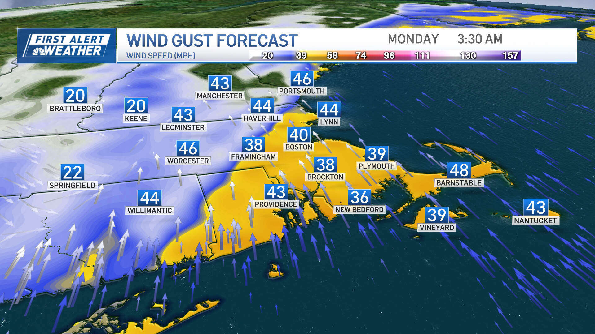
From 9 p.m. through the first part of the overnight, 40-45 mph gusts will become more common, and some pockets of isolated outages are expected to crop up. The core of the strongest wind will be from 4 a.m. to 9 a.m. Monday morning in eastern Mass., where 45-55 mph gusts at the coast — and 50-60 mph gusts on the south shore to Cape Cod — could cause outage numbers to rise substantially. A sharp wind shift is expected to arrive from west to east between mid-to-late morning, and wind gusts will decrease to the 25-35 mph range out of the west for the remainder of the day. Bring in any loose objects, holiday decorations and inflatables prior to the storm's arrival.
RAIN:
A few inland showers are possible before 11 a.m. tomorrow. Otherwise, scattered showers are expected to break out during the afternoon, more specifically around 1 p.m. in the city, and could come and go at times through the evening hours.
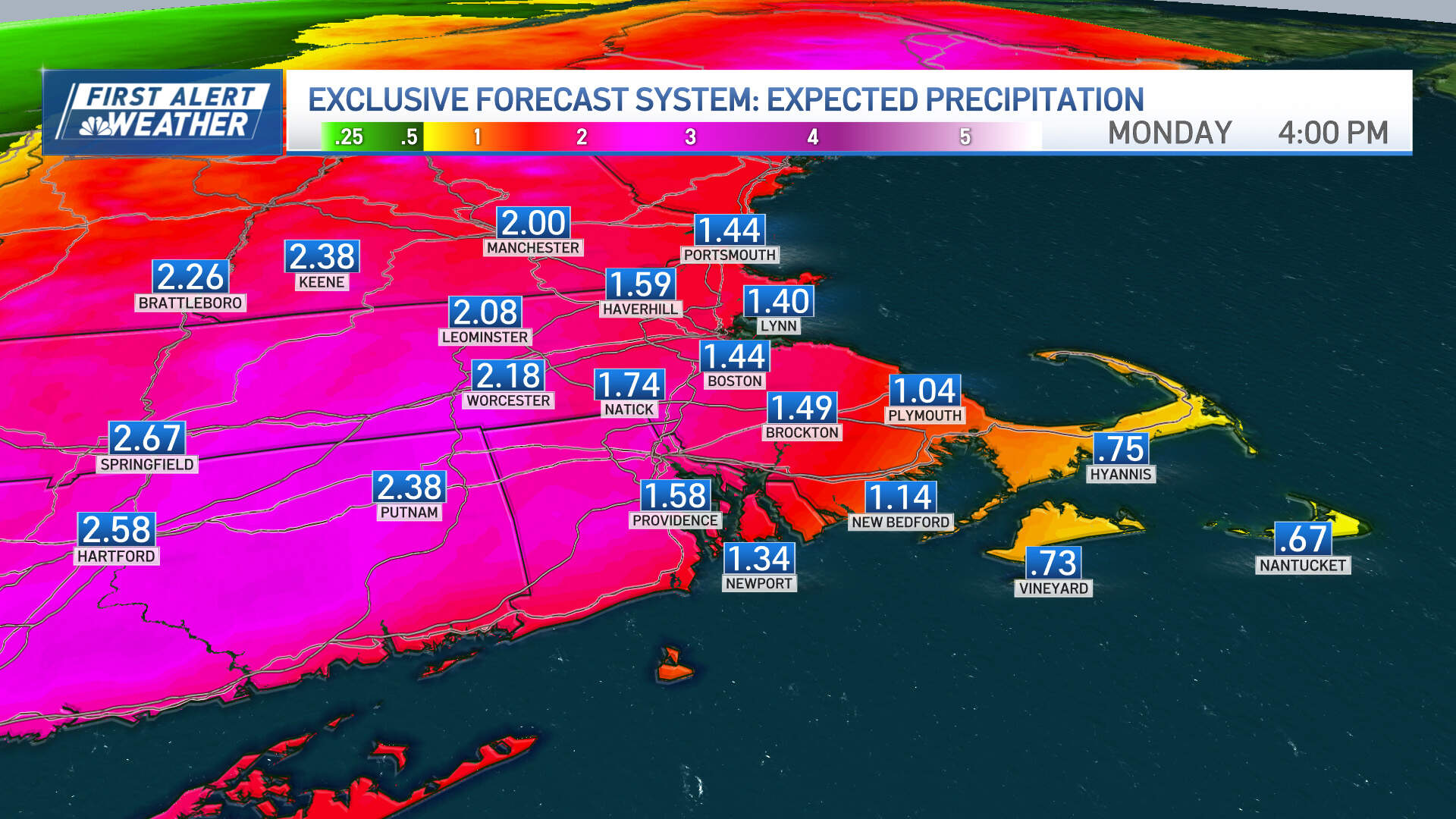
Steadier rain is expected to fill in outside of Interstate-495 from mid-afternoon onward. Rain will fall heavily at times overnight, with downpours and embedded thunder possible, particularly from midnight to pre-dawn Monday in and around the city of Boston. Areas of rain are expected to continue for the Monday morning commute, though the most intense band of rain should be shifting through Boston to the Cape during the mid-to-late morning.
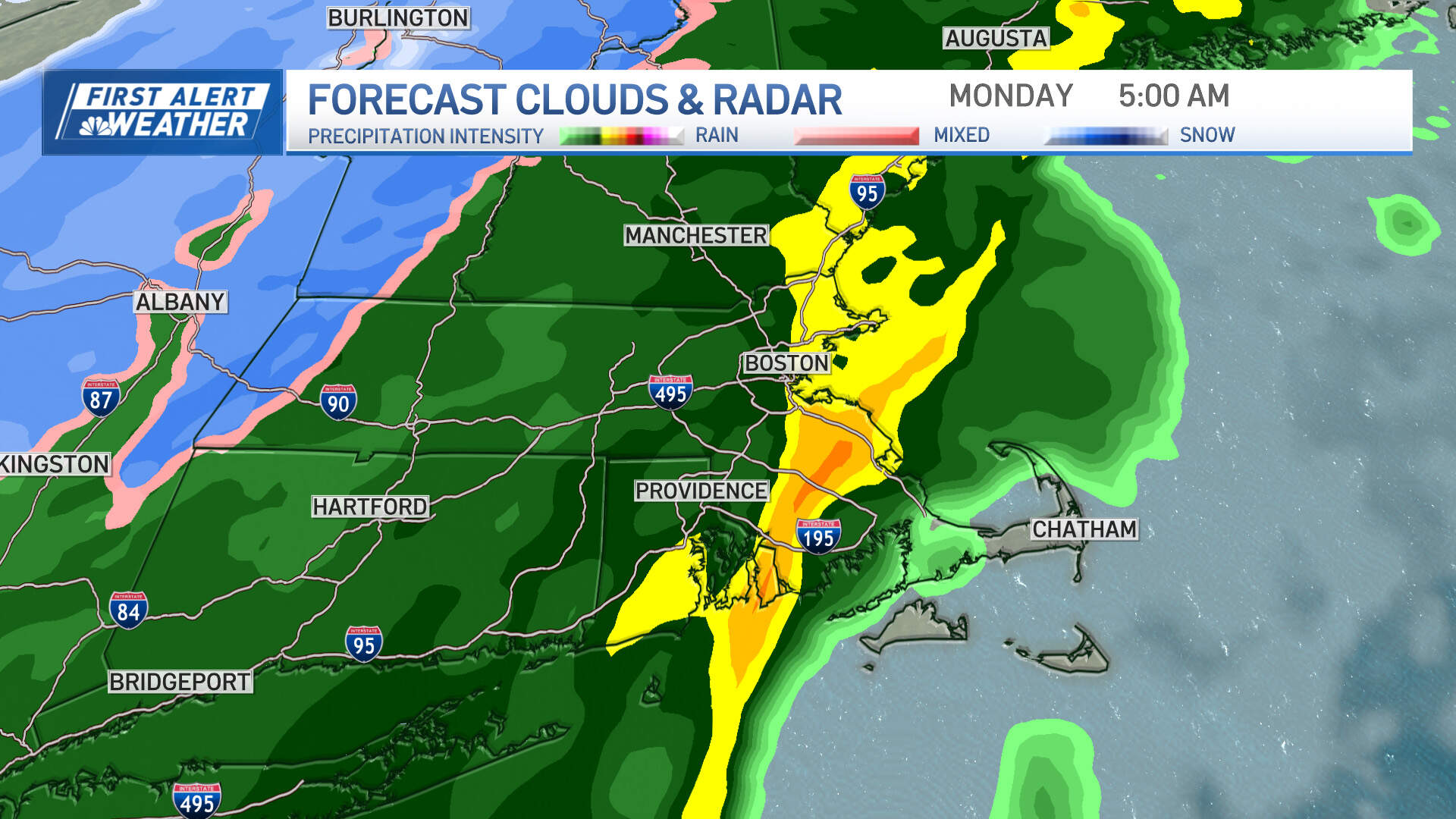
With a cold snap following the front, a brief snow shower is possible in central and western Mass. mid-to-late morning on Monday. Rainfall totals are expected to be approximately 1-2 inches with some locally higher totals hitting 2-3 inches in central and western Mass. and southwest New Hampshire. Slightly less is anticipated on Cape Cod (0.5 - 1 inches). Localized flooding is likely for the early part of the Monday morning commute along with some minor river and stream flooding. If possible, avoid driving before 9 a.m. Monday — otherwise, leave plenty of extra time to get to your destination and leave extra space between you and the cars in front of you. Clearing storm drains of leaves and sticks is also beneficial to help prevent flooding and keep water flowing sufficiently.
COASTAL CONCERNS:
Coastal flooding won't be a huge issue with this storm, although some minor coastal flooding is likely in the early Monday morning, two hours on both sides of high tide along the south coast of Mass. and Rhode Island.
BIG TEMPERATURE SWING:
It certainly hasn't felt like a December weekend. In fact, Boston is going to make a run at the record daily high of 64 degrees on Sunday afternoon — the original record was set back in 1907. We are expected to stay in the 50s overnight on Sunday before dropping steadily through the 40s on Monday morning and afternoon, and dropping further into the 30s by evening.
We'll stay at or slightly below average temperatures for the rest of this upcoming week with highs generally in the 40s (aside from drop to the 30s on Thursday) and quiet weather through at least the start of next weekend.