Advertisement
Oppressive heat again Thursday, but storms will bring relief in time for the Celtics parade
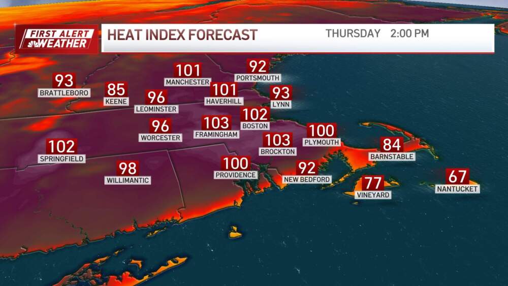
We're almost done with this scorching heatwave. After reaching a record-breaking 98 degrees yesterday afternoon, I wish I could say there would be some relief today. But not yet. The record high temperature to beat today is 98 degrees, set back in 1953 and we're going to make a run for it.
The humidity will remain oppressive today; it will feel like the low 100s in many areas. If you need to be be outside, take it easy. Drink plenty of fluids, find shade and take frequent breaks. Air conditioning is your friend — use it to cool down!
A cold front is moving in from the north and west this afternoon, bringing the potential for severe weather. The National Weather Service's Storm Prediction Center has highlighted much of New England for scattered severe storms and isolated severe storms. There are weak energetic disturbances in the atmosphere, which, combined with the heat and humidity, create conditions ripe for thunderstorms. Winds at 18,000 feet are steady at 30 to 40 mph, and storms should move from west to east at 35 to 40 mph. This helps ventilate storms, allowing them to last longer.
The primary threat from storms is damaging straight-line winds. Other threats include a potential for rotating storms, hail, torrential downpours and cloud-to-ground lightning.
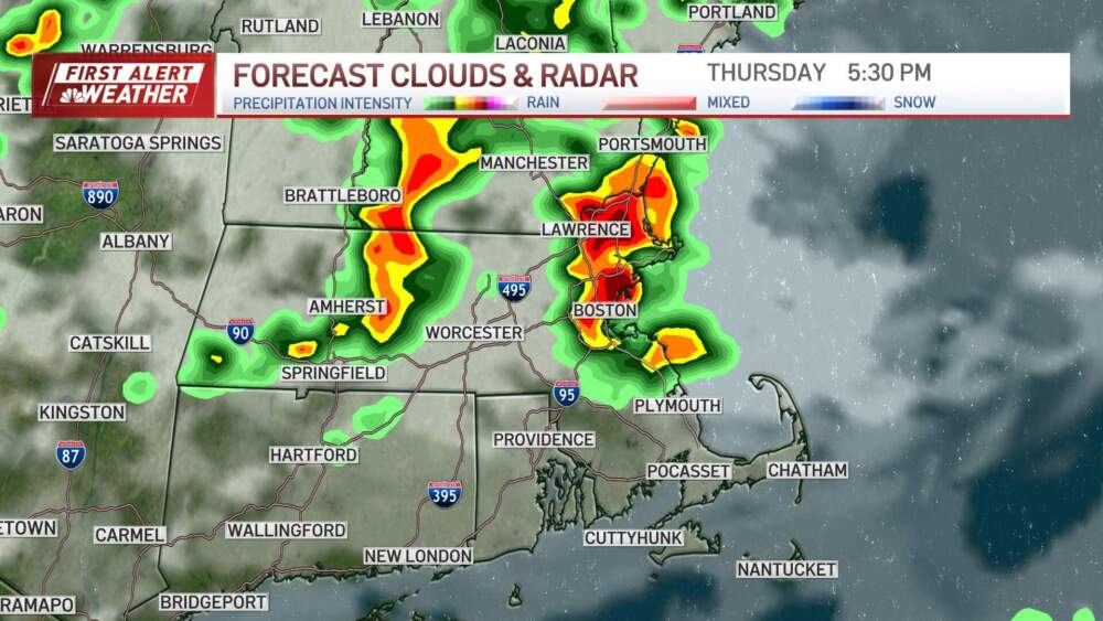
Areas of localized flash flooding may result today as well with 2 to 4 inches of rain falling in a short period of time in thunderstorms that develop. Isolated amounts up to 5 or 6 inches are possible, particularly in northern Maine and the Berkshires. Quicker moving storms will bring lower rainfall totals in thunderstorms, on the order of 1 to 2 inches, for the Boston and surrounding areas. Stay weather aware today and be ready to seek shelter indoors should you need to.
Friday will bring much cooler temperatures, generally in the 70s, with some communities briefly reaching the low 80s. There will be a northeast wind along the coastline and a southwest wind at the south coast, increasing the chance for showers. In fact, some downpours and even a few rumbles of thunder are expected off and on throughout the day — with enough coverage that it's worth having your raincoat or umbrella with you.